Complete Guide to Kinowa-no-ki (Sakata City, Yamagata Prefecture) | A Thorough Explanation of the History and Highlights of the Dewa Provincial Capital
What is Kinowa-no-ki?
Kinowa-no-ki (or Kinowa-no-saku) is an ancient Japanese fortified site located in Kinowa, Sakata City, Yamagata Prefecture. Designated as a national historic site under the name “Kinowa-no-ki Ruins,” it is the leading candidate for the location of the provincial capital (political center) of Dewa Province, built from the late Nara period to the Heian period.
The site has a nearly square shape with sides of approximately 720 meters, and covers a vast area of about 52 hectares. It played an important role as a center of control for the ancient Ritsuryo state in the Tohoku region. Since its discovery in 1931, continuous excavation surveys have revealed that it functioned for approximately 400 years, from the beginning to the end of the Heian period.
Historical Background of Shirowa-saku
Dewa Province and Ancient Fortifications
Dewa Province was one of the provinces established by the Ritsuryo state to govern the Tohoku region. In the early 8th century, the imperial court built fortifications in various locations to bring the people of the Tohoku region, known as the Emishi, under its control. A fortification refers to a defensive structure surrounded by fences or earthworks, serving as a base for military and administrative functions.
In Dewa Province, Akita Castle (Dewa-saku) was initially located in what is now Akita City, Akita Prefecture. However, it is believed that the provincial capital was moved further south to the Shonai region during the Hoki era (770s) at the end of the Nara period. The most likely candidate for this relocation site is Shirowa-saku, located in what is now Sakata City.
Historical Background of Shirowa-saku Construction
In the latter half of the 8th century, the Ritsuryo state was shifting its policy for governing Tohoku. The focus shifted from military conquest to the establishment of a more stable system of governance, and the location of the Dewa Provincial Government was strategically selected. The Shonai Plain was a fertile granary, and Sakata, near the mouth of the Mogami River, was a key point for trade along the Sea of Japan.
It is believed that the location of Shirowa Fort was chosen to maximize these economic and transportation advantages. Throughout the Heian period, Shirowa Fort continued to function as the political, economic, and cultural center of Dewa Province.
History and Results of Archaeological Excavations
From Discovery to the Present
The Shirowa Fort site was discovered in 1931 by local researchers. The following year, on April 25, 1932, it was designated a national historic site, recognizing its historical value. In 1981, it received additional designation, expanding its protected area.
Full-scale archaeological excavations began after World War II, and continuous investigations have been conducted since the 1960s, primarily by the Sakata City Board of Education. To date, numerous important remains have been identified, including the site of the government office, outer structures, road remains, and building remains.
Major Excavation Findings
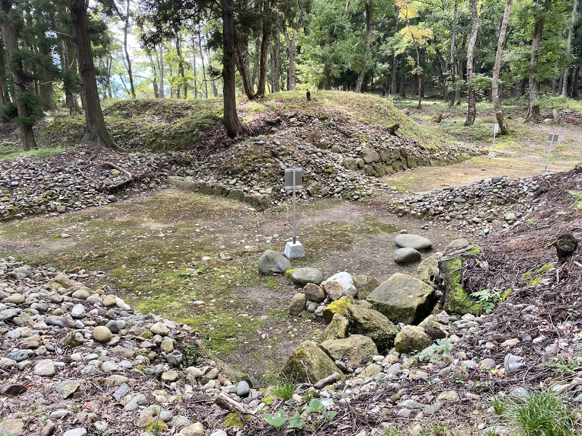
The excavations have gradually revealed the overall structure of the Shirowa Fort. The outer enclosure was found to be roughly square in shape, approximately 720 meters on each side, and surrounded by wooden and earthen walls. Gates were provided on all four sides of the outer enclosure, with the south gate playing a particularly important role as the main gate.
Within the site, it has been confirmed that the government office was located in the central area. The government office consisted of a group of buildings centered around the main hall, where ceremonies and government affairs were conducted. The location and size of the main hall are noteworthy in comparative studies with other ancient provincial capitals, as they indicate the status of the Dewa Provincial Capital.
Furthermore, numerous artifacts such as pottery, roof tiles, and iron products have been unearthed from the site, providing valuable information about the life and culture of the time. In particular, inscribed pottery is important evidence of administrative documents and the activities of officials.
Shirowa-saku in Records
Comparison with Historical Documents
While direct historical documents concerning Shirowa-saku are limited, descriptions of the Dewa Provincial Office can be found in ancient historical sources such as the *Shoku Nihongi* and *Nihon Koki*. By comparing these historical sources with archaeological findings, the historical position of Shirowa-saku has become clearer.
In particular, there are records indicating that the location of the Dewa Provincial Office was changed after the Iji no Kimi Azamaro Rebellion in 780 AD, and it is considered highly probable that the provincial office moved from Akita Castle to Shirowa-saku during this period.
Basis for Identifying the Provincial Office
There are several reasons why Shirowa-saku is considered the most likely candidate for the Dewa Provincial Office. Firstly, the scale and structure of the site correspond to a facility of the provincial office class. Secondly, the excavated artifacts have been continuously present throughout the Heian period, indicating long-term government function. Thirdly, the geographical conditions are ideal for the location of a provincial capital.
Compared with other candidate sites, Shirowa-saku occupies the most promising position, and many researchers recognize it as the site of the Dewa Provincial Capital.
Details of the Remains
Outer Enclosures
The outer enclosure of Shirowa-saku is an irregular square with sides of approximately 720 meters. The outer enclosure was composed of timber fences and earthen walls, serving both defensive functions and as a symbol of authority. The earthen walls were constructed using the rammed earth technique, and are estimated to be around 3 meters high.
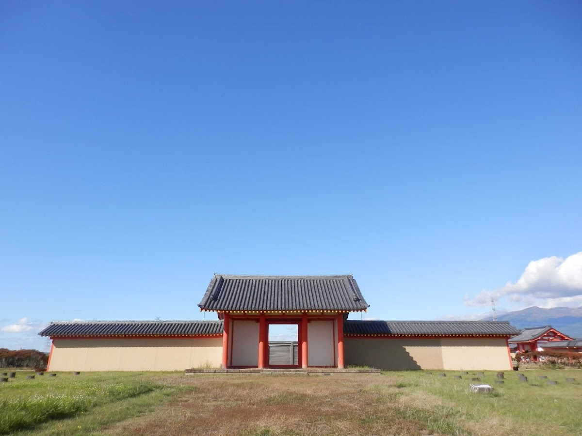
Gates were located on all four sides of the outer enclosure, and the remains of the South Gate and East Gate are particularly well-preserved. The South Gate served as the formal entrance to the government office and played an important role during ceremonies. The gate’s structure is thought to have been a highly formal eight-legged gate (yatsuashi-mon).
Government Office Site
The government office was located in the center of the Shirowa Fort and consisted of a group of buildings centered around the main hall. The main hall faced south, and a plaza (Chodoin) stretched out in front of it. This layout imitated the palace layout of Heijo-kyo and Heian-kyo, indicating that the central style was followed even in the provinces.
The main hall is estimated to have been approximately 5 bays by 2 bays, boasting an imposing presence as the central building of the Dewa Provincial Government. Other buildings such as side halls and a rear hall were also arranged around it, forming a space where government affairs and ceremonies were conducted.
Roads and Sections
Excavations have revealed that the interior of the Shirowa Fort was neatly divided into a grid-like road network. The main roads were 6 to 8 meters wide, with drainage ditches on both sides. This road network functioned as a transportation network connecting government facilities and the residences of officials.
It is believed that government buildings, warehouses, and workshops were located within each sectioned block. The warehouses, in particular, were important facilities for storing rice and other goods collected as taxes.
Excavated Artifacts
A wide variety of artifacts have been unearthed from the Shirowa Fort site. Among the pottery, a large number of Sue ware and Haji ware vessels have been found, indicating they were used as everyday tableware and storage containers. Numerous inscribed pottery pieces have also been unearthed, bearing characters such as “Kokuchu” (national kitchen), “Kitchen,” and “Kan” (mansion), providing important evidence of the site’s nature as a government facility.
Many roof tiles have also been unearthed, indicating that important buildings used tiled roofs. The rounded and flat eaves tiles are decorated with patterns such as lotus flowers, suggesting a high-status architectural style incorporating elements from the central government.
Among the iron artifacts, building components such as nails and staples, as well as weapons and tools such as knives and arrowheads, have been excavated. These are valuable historical materials illustrating the construction and maintenance of the fortifications, the daily lives of officials, and military activities.
Restored Facilities and Historical Park
History of the Preservation and Development Project
To widely convey the value of the Shirowa Fortifications site as a historical site, a preservation and development project was carried out from the late Showa period to the Heisei period. Based on the results of the excavation survey, Sakata City proceeded with a plan to restore the main remains and develop it as a historical park.
In the development project, while prioritizing the preservation of the remains, buildings and facilities were restored so that visitors could experience the atmosphere of the ancient fortifications. Currently, the South Gate and East Gate of the Government Office, and a part of the earthen wall have been restored, allowing visitors to imagine what it looked like in its heyday.
Highlights of the Restored Structures
The South Gate of the Government Office is an eight-legged gate-style building restored as the main gate of Shirowa Fortifications. The vermilion-painted pillars and white walls create a beautiful contrast, conveying the authority and prestige of ancient times. The gate is approximately 8 meters tall and is a full-scale reconstruction that recreates the technology of the time.
The East Gate has also been restored, indicating its role as an entrance on the east side of the Shirowa Fort. While slightly smaller than the South Gate, it has a similar eight-legged gate structure.
The Earthen Wall is a restored portion of the earthen wall that surrounded the outer fortifications. The layers of earth created using the rammed earth technique can be observed, allowing visitors to appreciate the advanced civil engineering technology of the ancient times. Tiles were laid on the top of the earthen wall, a measure taken to prevent erosion from rainwater.
Use as a Historical Park
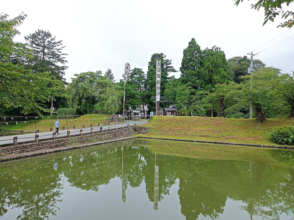
Currently, the Shirowa Fort site has been developed as a historical park and is popular with local residents and tourists. The vast grounds are covered with grass and have well-maintained walking paths, allowing visitors to leisurely explore the ruins.
Information boards and guides are installed within the park, allowing visitors to learn in detail about the location and characteristics of each structure. Especially around the site of the government office, markers indicating the building layout have been erected, making it easier to visually understand the scale of the former building complex.
In spring, cherry blossoms bloom, and in autumn, the autumn leaves create a beautiful landscape, making it a place where you can enjoy historical exploration and nature walks at the same time.
Tourist Information and Access
Basic Information
Location: Shirowa, Sakata City, Yamagata Prefecture
Designation: National Historic Site (Designated April 25, 1932, additional designation in 1981)
Area: Approximately 52 hectares
Managing Organization: Sakata City
Admission Fee: Free
Visiting Hours: Always open (however, no lighting at night)
Access Methods
By Train and Bus: Take the Shonai Kotsu bus bound for “Shirowa” from JR Uetsu Main Line “Sakata Station,” get off at the “Shirowa Sakuato” bus stop, and walk for about 5 minutes. Since the number of buses is limited, it is recommended to check the timetable in advance.
By Car: Approximately 15 minutes from the Nihonkai Tohoku Expressway “Sakata Chuo IC.” Free parking is available near the ruins, accommodating approximately 30 regular-sized cars.
Nearby Tourist Facilities
When visiting the Shirowa-saku ruins, visiting related facilities in the surrounding area will deepen your understanding of the history.
The Sakata City Museum (Kokyu Bunko) displays artifacts and related materials excavated from the Shirowa-saku ruins. You can learn in detail about the results of the excavation and the history of ancient Dewa Province. Furthermore, as part of the 1300th anniversary of the founding of Tagajo Castle, a limited-edition Shirowa-saku castle stamp was distributed, attracting attention from history enthusiasts.
Sakata City also boasts numerous other attractive cultural facilities, such as the Honma Museum of Art and the Domon Ken Memorial Museum. Sakata, facing the Sea of Japan, is also known for its fresh seafood, allowing you to enjoy the Shonai food culture along with your sightseeing.
Points to Note When visiting the Shirowa-saku ruins, keeping the following points in mind will make your visit more fulfilling.
- Visiting the Restored Structures: The restored structures of the government office’s south gate, east gate, and earthen wall best convey the atmosphere of the ancient fortifications. Observe the architectural style and structural details carefully.
- Confirming the Layout of the Government Office Site: Imagine the scale and structure of the government office at the time by checking the building layout indicated by the markers. Standing at the location of the main hall allows you to experience the perspective of ancient officials.
- Experiencing the Size of the Outer Enclosure: Walking around the outer enclosure, which measures 720 meters on each side, allows you to truly appreciate the immense size of the castle fortifications. You will be amazed by the advanced civil engineering technology of the time.
- Utilizing the Information Boards: Information boards placed throughout the site describe the details of the remains and their historical background. Reading them carefully will deepen your understanding.
- Seasonal Scenery: Enjoy the changing scenery of each season: cherry blossoms in spring, lush greenery in summer, colorful leaves in autumn, and snowscapes in winter. The area is especially crowded with visitors during cherry blossom season.
Historical Significance of Shirowa Fort
Role in Ancient Tohoku Administration
Shirowa Fort functioned as an important base for the Ritsuryo state’s control of the Tohoku region. As the Dewa Provincial Office, it oversaw the political, military, and economic affairs of the region and played a role in implementing the policies of the central government.
Particularly during the Heian period, relations with the Emishi people shifted from military conflict to trade and exchange, and Shirowa Fort also functioned as a cultural hub. Located in Sakata, a key point for trade along the Sea of Japan, it is believed to have played an important role as a window for exchange with the northern world.
Archaeological Value
The Shirowa Fort site is an extremely important archaeological site in the study of ancient fortifications. Comparative studies with other major fortifications in the Tohoku region, such as Tagajo (Miyagi Prefecture) and Akita Castle (Akita Prefecture), have revealed the realities of the ancient state’s regional governance.
In particular, the structure of the Shirowa Fort and the excavated artifacts reveal changes throughout the Heian period, making them valuable resources for understanding the transformation of local society during the transition from ancient to medieval times.
As a Regional Historical Heritage Site
The Shirowa Fort site is a representative historical heritage site of Sakata City and the Shonai region, forming the core of the region’s identity. As a symbol of Shonai’s history, which has continued since ancient times, it plays an important role in education and tourism.
Local elementary and junior high schools conduct local history lessons using the Shirowa Fort site as a subject, providing children with an opportunity to become familiar with local history. Furthermore, citizen-participatory excavation experience events are held, promoting the preservation and utilization of the historical heritage site throughout the community.
Summary
The Shirowa Fort site (Sakata City, Yamagata Prefecture) is an important archaeological site in ancient Japanese history, as it is the most likely candidate site for the Dewa Provincial Government, which flourished from the late Nara period to the Heian period. The vast site, approximately 720 meters on each side and covering a total area of 52 hectares, preserves the main remains of an ancient fortified settlement, including the administrative offices and outer structures, in excellent condition.
Since its discovery in 1931, continuous archaeological excavations have gradually revealed its overall structure. Currently, the south gate, east gate, and a portion of the earthen wall of the administrative office have been restored, and the site is widely open to the public as a historical park. These restored structures are invaluable examples of ancient architectural techniques and aesthetics, conveying them to the present day.
Shirowa Fort played a central role in the politics, economy, and culture of the ancient Tohoku region, serving as a base for the Ritsuryo state’s administration of the region and a key point for trade along the Sea of Japan. Its historical significance extends beyond local history, becoming an essential element in understanding ancient Japanese history as a whole.
Currently, the Shirowa Fort site is protected as a national historical site and utilized as a historical park enjoyed by the public. It is a precious place where one can reflect on the historical romance of over 1200 years ago amidst the natural scenery of the four seasons.
When you visit Sakata City in Yamagata Prefecture, be sure to stop by the Shirowa Fort Ruins and experience the glory of ancient Dewa Province and the lives of our ancestors. As you walk through the vast ruins, you will gain a real appreciation for the importance of the Tohoku region in ancient Japanese history.