Hotta-no-Saku (Akita Prefecture) Complete Guide: A Thorough Explanation of the Phantom Fortification Ruins of the Heian Period
What are the Hotta-no-Saku Ruins?
The Hotta-no-Saku Ruins are ancient fortification ruins from the early Heian period, located in Hotta, Daisen City, Akita Prefecture, and Hondōjōmawari, Misato Town, Senboku District. Approximately 1,200 years ago, the Ritsuryo state built this political and military base to unify the region. In 1931, it was designated a National Historic Site, the first in Akita Prefecture.
Its most distinctive feature is that its name is not mentioned at all in historical documents. For this reason, it is also called the “phantom fort,” and research continues to this day to determine what it was called at the time and what specific role it played.
The Hotta-saku site, boasting a scale and grandeur comparable to that of Tagajo Castle (Tagajo City, Miyagi Prefecture) and Akita Castle (Akita City), is an extremely important archaeological and historical site for understanding the expansionist policies of the ancient state in the Tohoku region.
Discovery and History of Hotta-saku
Circumstances of Discovery
The discovery of the Hotta-saku site dates back to around 1902 (Meiji 35). At that time, over 200 fence posts were accidentally discovered in a rice paddy in Chiya Village, Senboku District, Akita Prefecture (present-day Misato Town), where land consolidation was underway. This became the first clue indicating the existence of the Hotta-saku site.
Following this discovery, local researchers and historians began investigations, and the possibility of a large-scale ancient site existing in this area was pointed out.
Commencement of Full-Scale Investigation
In October 1930 (Showa 5), full-scale excavation began under the leadership of the Ministry of Education (at the time). This investigation gradually revealed the scale and structure of the ruins. The results of the investigation were highly regarded academically, and just six months later, on March 30, 1931 (Showa 6), it was designated a National Historic Site—the first such designation in Akita Prefecture—making it a site eligible for cultural property protection with exceptional speed.
Continued Excavation
Even after its designation as a National Historic Site, continuous excavation surveys have been conducted, primarily by the Akita Prefectural Board of Education. Post-war investigations, in particular, have advanced the analysis of the outer fence structure, the layout of the government office area, and the excavated artifacts, gradually revealing the true nature of the Haruta-saku fort.
Currently, the Akita Prefectural Board of Education’s Haruta-saku Site Research Office continues planned excavation surveys and research, resulting in a series of new discoveries.
Location and Structure
Geographical Location
The Haruta-saku site is located in the Senboku area of Daisen City, in southern Akita Prefecture, on a river terrace on the right bank of the Maruko River, a tributary of the Omono River. This location was a crucial transportation hub connecting the inland and coastal areas of Dewa Province in ancient times, making it a strategically important military and administrative point.
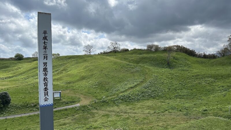
The surrounding area is still rural today, and the ruins are relatively well-preserved. The total area of the ruins covers approximately 870,000 square meters, making it one of the largest ancient fortifications in the Tohoku region.
Structure of the Outer Barrier
The most distinctive structure of the Haruta Barrier site is the outer barrier. This defensive structure encircles the entire site, exhibiting an irregular elliptical shape, approximately 1,370 meters north-south and 780 meters east-west. The outer barrier is a combination of wooden and earthen walls, and is estimated to have been over 3 meters high.
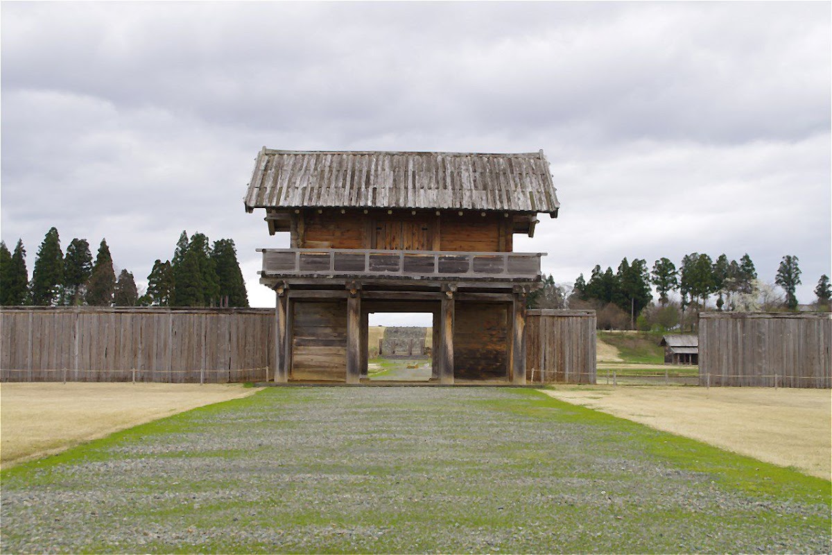
Gates were located on the east, west, north, and south sides of the outer barrier, with the southern gate being the most prestigious main gate. Excavations have revealed that the southern gate was an eight-legged gate, a magnificent structure with vermilion-painted pillars.
Layout of the Government Office Area
Inside the outer fence, a central facility known as the government office area was located. Excavations have revealed that this area was further demarcated by outer structures, and buildings such as the main hall, side halls, and rear hall were systematically arranged within it.
These building layouts share characteristics with central and local government facilities such as Heijo Palace and Tagajo, indicating that an administrative structure based on the Ritsuryo system was functioning.
Excavated Artifacts
The excavations have yielded a variety of artifacts, including pottery, iron objects, and wooden objects. In particular, written materials such as ink-inscribed pottery and wooden tablets are valuable resources for understanding the administrative activities and material management practices of the time.
Furthermore, clay horses and human figures (hitogata), believed to have been used in rituals, have been unearthed, indicating that the Haruta Fort was not merely a military facility, but also functioned as a site for ceremonies and rituals.
Theories Regarding the Hotta Fort
Debates Surrounding the Founding Date
Regarding the founding date of the Hotta Fort, the prevailing view, based on the results of archaeological excavations, is that it was founded in the early 9th century (early Heian period). Based on the chronology of excavated pottery and structural analysis of the buildings, it is believed that construction began in the early 800s.
However, the specific founding year cannot be definitively determined due to the lack of documentary records. Some researchers point to a connection with the Emishi subjugation campaigns that became active in the Tohoku region during the reign of Emperor Saga (809-823).
Various Theories Regarding the End of the Fort
Regarding the end of the Hotta Fort, the mainstream view is that it ended in the latter half of the 10th century. This period coincides with a time when the Ritsuryo state’s control over Tohoku changed and the power of local powerful families increased.
Evidence of fire has been confirmed at the site, and it has been suggested that it may have been suddenly abandoned due to some incident, but the details are unknown. Furthermore, there is a theory that its functions gradually diminished, and the nature of its eventual demise remains a subject for future research.
The Name Problem of Hotta-saku
The biggest mystery is what name Hotta-saku was called in ancient times. Because there are no records in historical documents, attempts have been made to identify it with other unconfirmed fortifications that appear in documents, such as “Kawabe-fu” and “Ogachi-jo.”
Recent research has proposed theories suggesting it may have been the Dewa Provincial Office, or that it may have been “Ogachi-saku,” which functioned as a branch castle of Akita Castle. However, no conclusive evidence has been found, and further archaeological excavations and advancements in historical document research are awaited.
Interpretation of Function and Role
Regarding the function of Hotta-saku, there are various views, including theories that it was a military facility, an administrative facility, or a combined facility of both.
The current mainstream interpretation is a complex function theory, suggesting that it served as a political and military base while also functioning as a ceremonial site. Analysis of excavated artifacts has revealed that a variety of activities took place at the site, including the accumulation and management of supplies, tax collection, military mobilization, and religious ceremonies.
Hotta-saku General Information Center and Visitor Facilities
Overview of the Hotta-saku General Information Center
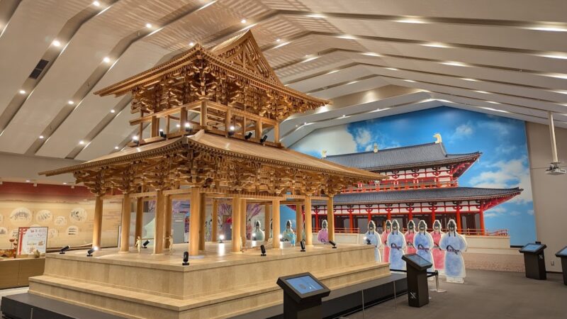
The Hotta-saku General Information Center is the base for visitors to the Hotta-saku site. This facility provides comprehensive information and exhibits about the Hotta-saku site.
The center displays a topographical diorama model (1/500 scale) and a model of the southern gate of the outer fence (1/5 scale), allowing visitors to visually understand the overall layout of the site. A wealth of actual materials unearthed during excavations, such as timber, pottery, and iron artifacts, are also on display.
A large screen shows explanatory videos incorporating animation, making it easy to learn about the history and structure of Hotta-saku. Even first-time visitors will gain a deeper understanding of the site by watching these videos.
Akita Prefectural Buried Cultural Properties Center and Research Office
The Haruta-saku Site Research Office is located within the Akita Prefectural Buried Cultural Properties Center, across from the South Gate of the outer fortifications. Here, planning for ongoing excavation surveys, organizing and analyzing excavated artifacts, and publishing research results are all conducted.
There is also a public exhibition space where visitors can learn about the latest research findings and developments. Furthermore, during periods when the excavation site is open to the public, there are opportunities to observe actual excavation work.
Development as a Historical Park
The Haruta-saku Site is being developed as a historical park, allowing visitors to walk around and explore the ruins. Signs and explanatory panels have been installed at parts of the outer fortifications and gate locations, allowing visitors to experience the scale of the ancient fortifications.
The reconstructed South Gate of the outer fortifications is a particular highlight, showcasing a magnificent example of Heian period architectural techniques. Walking paths are maintained in the surrounding area, allowing visitors to enjoy the historical site while appreciating the changing seasons.
Major Cultural Properties and Surrounding Tourist Attractions in Daisen City
Cultural Properties of Daisen City
Daisen City, home to the Haruta-saku Ruins, boasts numerous other cultural properties. These include the former Ikeda Family Garden (a nationally designated Important Cultural Property) and the former Ikeda Family Residence (a prefecturally designated Tangible Cultural Property), among other historical buildings dating from the Edo period to the modern era.
Furthermore, Daisen City is known for the “Omagari Fireworks Festival,” a national fireworks competition, making it a fascinating region where traditional and modern cultures coexist.
Surrounding Tourist Attractions
Around the Haruta-saku Ruins are several of Akita Prefecture’s most representative tourist destinations, such as the Kakunodate Samurai Residences and Lake Tazawa. Kakunodate is approximately 30 minutes away by car, and Lake Tazawa is about 40 minutes away, allowing for itineraries that combine historical exploration with nature sightseeing.
Access
Access by Public Transportation
By JR
- The nearest station is JR Ou Main Line “Omagari Station”
- Approximately 8km from Omagari Station to the Haruta Fort Ruins
- Approximately 15 minutes by taxi from the station
- If using a local bus, get off at the Ugo Kotsu Bus “Haruta” bus stop and walk for approximately 10 minutes.
By Shinkansen
- Get off at Akita Shinkansen “Omagari Station”
- Approximately 3 hours 30 minutes from Tokyo Station to Omagari Station
- Approximately 1 hour from Morioka Station to Omagari Station
Access by Car
Using Expressways
- Approximately 10 minutes (approximately 6km) from Akita Expressway “Omagari IC”
- Approximately 1 hour 30 minutes from Tohoku Expressway “Morioka IC” via Akita Expressway
Using General Roads
- Approximately 5 minutes from National Route 13 “Haruta” intersection
- Approximately 50 minutes from central Akita City via National Route 13
Parking
- Free parking available at the Haruta-saku General Information Center (approximately 50 regular cars)
- Parking space also available at the Akita Prefectural Buried Cultural Properties Center
Visiting Information
Opening Hours
- The historical site is always open (free to visit)
- Haruta-saku General Information Center: 9:00 AM – 4:30 PM
- Closed: Mondays (or the following day if Monday is a public holiday), New Year holidays
Admission Fee
- Historical site visit: Free
- Haruta-saku General Information Center: Free
Estimated Time Required
- Visit to the General Information Center: Approximately 30 minutes
- Walking around the entire historical site: Approximately 1-2 hours
Contact Information
Akita Prefectural Board of Education Haruta-saku Site Research Office
- Address: 20 Ushijima, Haruta, Daisen City, Akita Prefecture 014-0802
- Phone: 0187-69-2397
Haruta-saku General Information Center
- Address: 95 Nakayachi, Haruta, Daisen City, Akita Prefecture
- Phone: 0187-69-2397
Daisen City Board of Education Cultural Properties Protection Division
- Phone: 0187-63-8972
Value and Future Prospects of the Haruta-saku Site
Academic Value
The Haruta-saku site is an extremely important archaeological site for elucidating the governance system of the ancient state in the Tohoku region. Given the scarcity of documentary materials, it is a valuable example that concretely demonstrates the reality of local governance during the Heian period through archaeological methods.
In particular, it is indispensable for clarifying the overall picture of the Ritsuryo state’s management of Tohoku through comparative research with other ancient castles and fortifications such as Tagajo and Akitajo.
Utilization as a Regional Resource
The Haruta-saku site is utilized as an important regional resource of Daisen City for tourism promotion and educational activities. Local elementary and junior high schools use the Haruta-saku site as teaching material for local history lessons, providing children with an opportunity to learn about the region’s history.
Furthermore, festivals and events are held at the historical site in summer and winter, serving as a place for interaction between local residents and visitors.
Future Investigations and Preservation
Planned archaeological excavations are still ongoing at the Haruta-saku site, with new discoveries being made every year. Continued investigations are expected to reveal the full extent of the site and solve its mysteries.
At the same time, balancing the appropriate preservation and utilization of the historical site is a crucial issue. Akita Prefecture and Daisen City are working to achieve both the protection and public use of the site based on the basic plan for historical site development.
Summary
The Haruta-saku site is an ancient fortified settlement built approximately 1,200 years ago during the early Heian period, and is a representative nationally designated historical site of Akita Prefecture. While shrouded in mystery as a “phantom fort” with no historical records, its true nature is gradually being revealed through continuous archaeological excavations.
The Hotta-saku ruins, boasting a scale comparable to Tagajo and Akita Castle, are an essential historical site for understanding the Ritsuryo state’s rule over the Tohoku region, and possess high value both academically and as a tourist attraction.
By combining a visit to the exhibits at the Hotta-saku Information Center with a stroll through the historical site, you can experience the history of ancient Tohoku. When visiting Akita Prefecture, be sure to visit the Hotta-saku ruins and feel the spirit of the Heian period.
Its easy accessibility, approximately 15 minutes by car from Omagari Station, is another attractive feature. Combining a visit to nearby tourist spots such as Kakunodate and Lake Tazawa will allow you to enjoy a more fulfilling Akita sightseeing experience.